
Looking for the best GIS Technology for your Information Technology work?
Comparing ECHO™ vs Hexagon Geomedia
ECHO™ has 0 Reviews and a Rating of 0/5 compared to Hexagon Geomedia with 1 Reviews, 2.5/5 Rating respectively. ECHO™ is a "GIS" software technology primarily used in "Information Technology" domain, by contrast Hexagon Geomedia is a "GIS" software technology primarily used in "O&G_Geology, O&G_Geophysics, Solar, Wind, Other Energies, Research & Development, Information Technology, Corporate" domain.


Table Setting
ECHO™
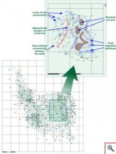
Subsystem ECHO™ is designed to analyze production data in order to obtain additional information characterizing geological features of producing field. In addition ECHO should be used as information support in petroleum production simulation and management.

Hexagon Geomedia
Hexagon GeoMedia has 40+ years of history. But lately, it’s taken a bit of a slide. Nevertheless, Geomedia is still solid as GIS software. Especially, when you pair it up with ERDAS Imagine, you get arguably the best suite in remote sensing.
Free Demo
By submiting the form you can apply for free Demo.
Hexagon Geomedia
Table Setting
ECHO™
Subsystem ECHO™ is designed to analyze production data in order to obtain additional information characterizing geological features of producing field. In addition ECHO should be used as information support in petroleum production simulation and management.
Unit Score : 0 Request Quote
Hexagon Geomedia
Hexagon GeoMedia has 40+ years of history. But lately, it’s taken a bit of a slide. Nevertheless, Geomedia is still solid as GIS software. Especially, when you pair it up with ERDAS Imagine, you get arguably the best suite in remote sensing.
Unit Score : 0 Request Quote
OVERVIEW
| Product Version: | 1.00 | 2.50 | |
|---|---|---|---|
| Release Date: | 18 Sep, 2022 | ||
| Product User Discipline: | Academicians | ||
| Product Summary: | Subsystem ECHO™ is designed to analyze production data in order to obtain additional information characterizing geological features of producing field. In addition ECHO should be used as information support in petroleum production simulation and management. | Hexagon GeoMedia has 40+ years of history. But lately, it’s taken a bit of a slide. Nevertheless, Geomedia is still solid as GIS software. Especially, when you pair it up with ERDAS Imagine, you get arguably the best suite in remote sensing. | |
| Product Keywords: | Geology Designer | ||
| Product Status: | Commercial | Commercial | |
| Development Team HQ: | India | ||
| Development Team Size: | 5 | ||
| Major Release Period: | Annual | ||
| Minor Release Period: | Quarterly | ||
| Cost Structure: | Single Package (Recurring) | ||
| Average Cost Per Seat $: | 0.00 | 5,050.00 | |
| Average Maintenance Rate %: | 0.00 | 10.00 | |
| Free Trial available: | Yes |
ATTRIBUTE
COMPATIBILITY
| Compatible With: |
|
|---|
| Integration Method: |
|
|
|---|
USER REVIEW
| Overall Rating: | 0 Reviews | 1 Reviews | |
|---|---|---|---|
| Design: | N/A | 2.5 | |
| Features: | N/A | 2.5 | |
| Complexity: | N/A | 2.5 | |
| Performance: | N/A | 2.5 | |
| Precision: | N/A | 2.5 | |
| Support: | N/A | 2.5 | |
| Value: | N/A | 2.5 | |
| Latest Reviews: | N/A |
Request Quote
By submiting the form you can request for Quote.
ECHO™
Request Quote
By submiting the form you can request for Quote.
Hexagon Geomedia