


AUSTIN (KXAN) — Lake Buchanan, Inks Lake, Lake LBJ, Lake Marble Falls, Lake Travis and Lake Austin — these six reservoirs make up our Central Texas Highland Lakes.
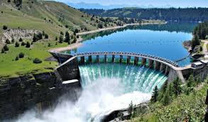
Each lake starts and ends with a man-made dam, segmenting the Lower Colorado River.
The lakes help maintain our water supply as well as provide hydroelectricity, a source of renewable energy found to be key in fighting climate change.
But most importantly, these dams and lakes help manage and prevent flooding from heavy rain events — a challenging feat living in “Flash Flood Alley.”
Lake Travis is Austin’s flood pool, protecting the city and areas downstream.
Our latest drought monitor shows areas in Central Texas at moderate to severe drought levels. Officials say to not let your guard down, however, as floods can happen even during a drought.
John Hofmann with the Lower Colorado River Authority says, “we live in an area that is especially prone to droughts and weather extremes, so, on one hand, we live in an arid part of the world and state, we also live in an area known as Flash Flood Alley.”
Many of our largest flooding events, including the October 2018 flood, came after a significant drought event earlier in the year. Flooding events in Austin have also taken place on days that start with sunshine.
The Hill Country has rocky, shallow soil and noteworthy changes in elevation. When heavy rain falls in the area, little can be held by the ground. Instead, it flows toward lower elevations, collecting into our Highland Lakes.
“I think that the message for the Colorado River basin and its residents is to always maintain a state of readiness and understand that we tend to go between these extremes from parching drought that is a normal part of our everyday life,” Hoffman says.
“So events that can result in 10 to 20 inches of rain in a short amount of time which means we open up all these gates behind me. So you have to stay ready and be aware of what is going on.”